
Note: the three little dashes on the puzzle –functions for clearing the puzzle, zooming in and out and printing and down loading the hard copy of the puzzle solution.
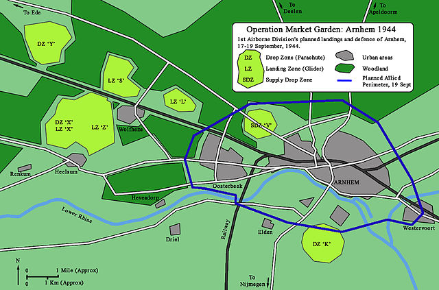
Operation Market Garden was an Allied military operation during the Second World War fought in the German-occupied Netherlands from 17 to 25 September 1944. Its objective was to create a salient spanning 64 miles (103 km) into German territory with a bridgehead over the Nederrijn (Lower Rhine River), creating an Allied invasion route into northern Germany.[8] This was to be achieved by two sub-operations: seizing nine bridges with combined American and British airborne forces (“Market“) followed by British land forces swiftly following over the bridges (“Garden“).
The airborne operation was undertaken by the First Allied Airborne Army with the land operation by the British Second Army, with XXX Corps moving up the centre supported by VIII and IX Corps on their flanks. The airborne soldiers, consisting of paratroops and glider-borne troops numbering around 35,000,[9][10] were dropped at sites where they could capture key bridges and hold the terrain until the land forces arrived. The land forces consisted of ten armoured and motorised brigades with a similar number of soldiers. The land forces advanced from the south along a single road surrounded by flood plain on both sides. The plan anticipated that they would cover the 103 km (64 miles) from their start to the bridge across the Rhine in 48 hours. About 100,000 German soldiers were in the vicinity to oppose the allied offensive.[11] It was the largest airborne operation of the war up to that point.[e]
The operation succeeded in capturing the Dutch cities of Eindhoven and Nijmegen along with many towns, and a few V-2 rocket launching sites. It failed in its most important objective: securing the bridge over the Rhine at Arnhem. The Germans slowed and then halted the armoured brigades advancing from the south before they reached the Rhine. The British 1st Airborne Division was unable to secure the bridge and was withdrawn from the north side of the Rhine after suffering 8,000 dead, missing, and captured out of a complement of 10,000 men.[13] When the retreat order came there were not enough boats to get everyone back across the river. The Germans subsequently rounded up most of those left behind, but some of the British and Polish paratroopers managed to avoid capture by the Germans and were sheltered by the Dutch underground until they could be rescued in Operation Pegasus on 22 October 1944.[14] Historians have been critical of the planning and execution of Operation Market Garden. Antony Beevor said that Market Garden “was a bad plan right from the start and right from the top”.[15]
The Germans counterattacked the Nijmegen salient but failed to retake any of the Allied gains. Arnhem was finally captured by the Allies in April 1945, towards the end of the war.
Geography
[edit source]Short US Army video of the overall plan for Operation Market Garden
Highway 69 (later nicknamed “Hell’s Highway”) leading through the planned route was two narrow lanes, partly raised above a surrounding flat terrain of polder or floodplain. The ground on either side of the highway was in places too soft to support tactical vehicle movement and there were numerous dikes and drainage ditches. Dikes tended to be topped by trees or large bushes, and roads and paths were lined with trees. In early autumn this meant that observation would be seriously restricted.[16]
There were six major water obstacles between the XXX Corps’ jumping-off point and the objective of the north bank of the Lower Rhine River: the Wilhelmina Canal at Son en Breugel 100 feet (30 m) wide; the Zuid-Willems Canal at Veghel 80 feet (20 m); the Maas River at Grave 800 feet (240 m); the Maas-Waal Canal 200 feet (60 m); the Waal River at Nijmegen 850 feet (260 m); and the Rhine at Arnhem 300 feet (90 m).[17] The plan was for airborne forces to seize bridges across all these obstacles nearly simultaneously – any failure to do so would result in delay or defeat. In case bridges were demolished by the Germans, XXX Corps had plans to rebuild them. To this end, a vast quantity of bridging material was collected, along with 2,300 vehicles to carry it and 9,000 engineers to assemble it.[17]
Although the area is generally flat with less than 30 feet (9 m) of variation in altitude, Lieutenant-General Brian Horrocks, commander of XXX Corps, recalled that “The country was wooded and rather marshy, which made any outflanking operation impossible.”[18] Two important hill areas, 300 feet (90 m) high, were some of the highest ground in the Netherlands: one northwest of Arnhem and one in the 82nd Airborne Division’s zone, the Groesbeek ridge. Seizure and defence of this elevated terrain was considered vital to holding the highway bridges.[16]